- Core Journal of China
- DOAJ
- Scopus
- Chinese Scientific and Technical Papers and Citations (CSTPC)
- Chinese Science Citation Database (CSCD)
| Citation: |
LIU Jiufen,ZHAO Xiaofeng,HOU Hongxing,et al. Exploration on the Stratification of the Ground Substrate Survey and the Design and Construction of Its Testing Indicator System[J]. Rock and Mineral Analysis,2024,43(1):16−29. DOI: 10.15898/j.ykcs.202310080157

|
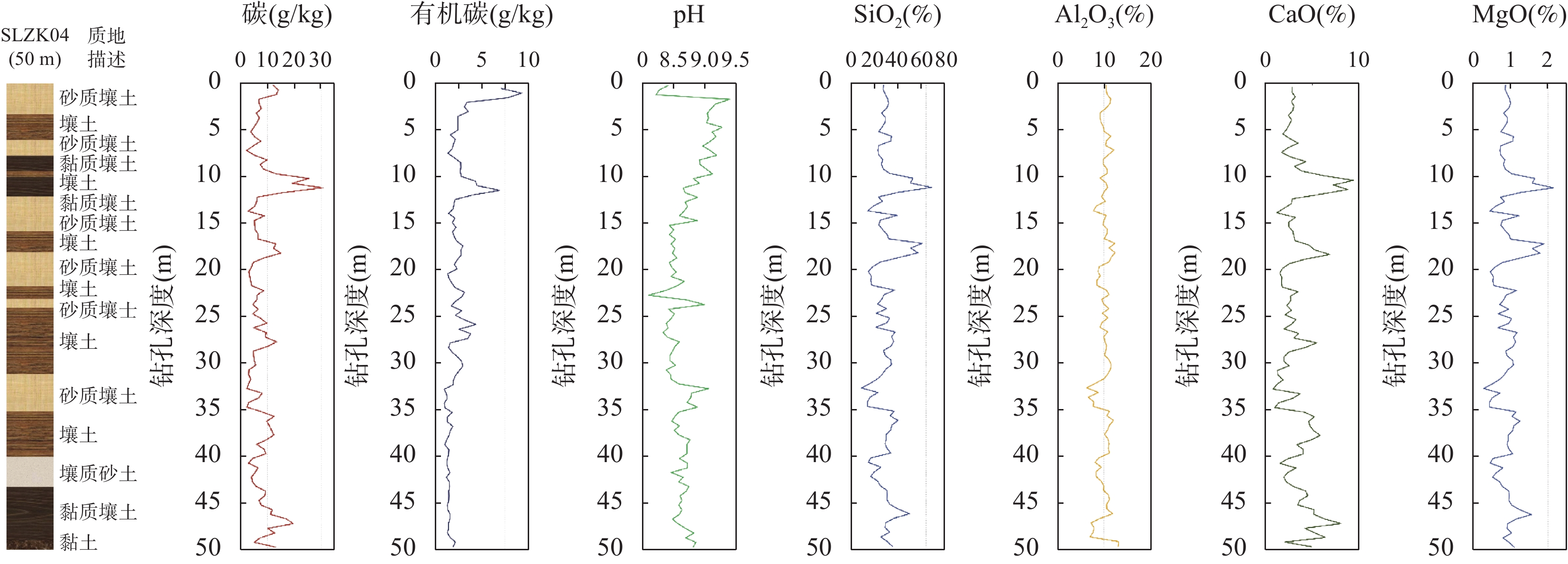
The ground substrate layer is the main carrier of the material and energy cycle of the earth’s surface. At present, it is essential to have a suitable ground substrate stratification and testing index system for conducting an effective ground substrate survey. Based on the pilot results of the ground substrate survey project in the past three years, and the links between ground substrate with Multi-Objective Regional Geochemical Surveys, the Third National Soil Census and the National Detailed Survey of Soil Pollution on Agricultural Land, the ground substrate can be vertically divided into three layers: the surface production layer (0-2m), the middle ecological layer (2-10m) and the deep sedimentary layer (10-20m). If the depth of the base layer is less than 20m, the ground substrate is exposed to the bedrock. The surface layer mainly serves the national food security, and mainly collects data; the middle layer focuses on territorial space planning, and is the focus of investigation; the deep layer is mainly to explore the ground substrate from bedrock-deep layer-middle layer-surface layer succession pattern, a small amount of engineering control is appropriate. The proposed vertical stratified test index system for ground substrate includes 4 required indices and
| [1] |
侯红星, 张蜀冀, 鲁敏, 等. 自然资源地表基质层调查技术方法新经验——以保定地区地表基质层调查为例[J]. 西北地质, 2021, 54(3): 277−288. doi: 10.19751/j.cnki.61-1149/p.2021.03.026
Hou H X, Zhang S J, Lu M, et al. Technology and method of the ground substrate layer survey of natural resources: Taking Baoding area as an example[J]. Northwestern Geology, 2021, 54(3): 277−288. doi: 10.19751/j.cnki.61-1149/p.2021.03.026
|
| [2] |
殷志强, 秦小光, 张蜀冀, 等. 地表基质分类及调查初步研究[J]. 水文地质工程地质, 2020, 47(6): 8−14. doi: 10.16030/j.cnki.issn.1000-3665.202010065
Yin Z Q, Qin X G, Zhang S J, et al. Preliminary study on classification and investigation of surface substrate[J]. Hydrogeology & Engineering Geology, 2020, 47(6): 8−14. doi: 10.16030/j.cnki.issn.1000-3665.202010065
|
| [3] |
殷志强, 陈自然, 李霞, 等. 地表基质综合调查: 内涵、分层、填图与支撑目标[J]. 水文地质工程地质, 2023, 50(1): 144−151. doi: 10.16030/j.cnki.issn.1000-3665.202205004
Yin Z Q, Chen Z R, Li X, et al. Connotation, layering, mapping and supporting objectives of the integrated survey of ground substrates[J]. Hydrogeology & Engineering Geology, 2023, 50(1): 144−151. doi: 10.16030/j.cnki.issn.1000-3665.202205004
|
| [4] |
侯红星, 葛良胜, 孙肖, 等. 地表基质在中国黑土地资源调查评价中的应用探讨——基于黑龙江宝清地区地表基质调查[J]. 自然资源学报, 2022, 37(9): 2264−2276. doi: 10.31497/zrzyxb.20220905
Hou H X, Ge L S, Sun X, et al. A study on the application of ground substrate in the survey and evaluation of China’s black soil resources: Based on ground substrate survey in Baoqing, Heilongjiang Province[J]. Journal of Natural Resources, 2022, 37(9): 2264−2276. doi: 10.31497/zrzyxb.20220905
|
| [5] |
董天钰, 刘晓煌, 常铭, 等. 浅析地表基质的本质内涵及研究方向[J]. 西北地质, 2023, 56(4): 213−217. doi: 10.12401/j.nwg.2023040
Dong T Y, Liu X H, Chang M, et al. Analysis on the essential connotation and research direction of surface substrate[J]. Northwestern Geology, 2023, 56(4): 213−217. doi: 10.12401/j.nwg.2023040
|
| [6] |
朱永官, 李刚, 张甘霖, 等. 土壤安全: 从地球关键带到生态系统服务[J]. 地理学报, 2015, 70(12): 1859−1869. doi: 10.11821/dlxb201512001
Zhu Y G, Li G, Zhang G L, et al. Soil security: From Earth’s critical zone to ecosystem services[J]. Acta Geographica Sinca, 2015, 70(12): 1859−1869. doi: 10.11821/dlxb201512001
|
| [7] |
肖春蕾, 聂洪峰, 刘建宇, 等. 生态-地质作用模式: 诠释表生地质过程与生态特征的耦合[J]. 中国地质调查, 2021, 8(6): 9−24. doi: 10.19388/j.zgdzdc.2021.06.02
Xiao C L, Nie H F, Liu J Y, et al. Ecological and geological interaction model: The coupling of supergene geological processes and ecological characteristics[J]. Geological Survey of China, 2021, 8(6): 9−24. doi: 10.19388/j.zgdzdc.2021.06.02
|
| [8] |
张贺, 王绍强, 王梁, 等. 自然资源要素综合观测指标体系探讨[J]. 资源科学, 2020, 42(10): 1883−1899. doi: 10.18402/resci.2020.10.06
Zhang H, Wang S Q, Wang L, et al. Discussion on the indicator system of comprehensive observation of natural resource elements[J]. Resources Science, 2020, 42(10): 1883−1899. doi: 10.18402/resci.2020.10.06
|
| [9] |
中华人民共和国人民政府. 国务院关于开展第三次全国土壤普查的通知[EB/OL].https://www.gov.cn/gongbao/content/2022/content_5678068.htm, 2023-8-18.
The State Council, The People’s Republic of China. State council on the conduct of the Third National Soil Census[EB/OL].https://www.gov.cn/gongbao/content/2022/content_5678068. htm, 2023-8-18.
|
| [10] |
中华人民共和国生态环境部. 关于印发全国土壤污染状况详查样品分析测试方法系列技术规定的通知 [EB/OL].https://www.mee.gov.cn/gkml/hbb/bgth/201711/t20171106_425226.htm, 2023/08/18.
Ministry of Ecology and Environment of the People’s Republic of China. Circular on the issuance of a series of technical regulations on analytical test methods for samples from the national detailed investigation of soil pollution situation[EB/OL].https://www.mee.gov.cn/gkml/hbb/bgth/201711/t20171106_425226.htm, 2023/08/18.
|
| [11] |
张甘霖, 宋效东, 吴克宁. 地球关键带分类方法与中国案例研究[J]. 中国科学: 地球科学, 2021, 51(10): 1681−1692. doi: 10.1360/SSTe-2020-0249
Zhang G L, Song X D, Wu K N. Earth’s critical zone classification methodology and case study of China[J]. Science China (Earth Sciences), 2021, 51(10): 1681−1692. doi: 10.1360/SSTe-2020-0249
|
| [12] |
袁国礼, 侯红星, 刘建宇, 等. 服务生态文明的生态地质调查工作方法浅析——以地表基质调查为例[J]. 西北地质, 2023, 56(3): 30−38. doi: 10.12401/j.nwg.2023065
Yuan G L, Hou H X, Liu J Y, et al. Introduction to the methods of ecology-geological survey for servicing ecological civilization: Example from ecology−supporting sphere survey[J]. Northwestern Geology, 2023, 56(3): 30−38. doi: 10.12401/j.nwg.2023065
|
| [13] |
王京彬, 卫晓锋, 张会琼, 等. 基于地质建造的生态地质调查方法——以河北省承德市国家生态文明示范区综合地质调查为例[J]. 中国地质, 2020, 47(6): 1611−1624. doi: 10.12029/gc20200601
Wang J B, Wei X F, Zhang H Q, et al. The eco-geological survey based on geological formation, exemplified by integrated geological survey of national ecological civilization demonstration area in Chengde City, Hebei Province[J]. Geology in China, 2020, 47(6): 1611−1624. doi: 10.12029/gc20200601
|
| [14] |
Zhou J, Wang Y, Tong Y, et al. Regional spatial variability of soil organic carbon in 0-5m depth and its dominant factors[J]. Catena, 2023, 231: 107326. doi: 10.1016/j.catena.2023.107326
|
| [15] |
殷志强, 郝爱兵, 吴爱民, 等. 承德自然资源综合调查主要进展与全国自然资源综合调查总体思路[J]. 地质通报, 2022, 41(12): 2087−2096. doi: 10.12097/j.issn.1671-2552.2022.12.001
Yin Z Q, Hao A B, Wu A M, et al. The key progress in Chengde and the national proposal of the integrated survey of natural resources[J]. Geological Bulletin of China, 2022, 41(12): 2087−2096. doi: 10.12097/j.issn.1671-2552.2022.12.001
|
| [16] |
陶志富, 葛璐璐, 陈华友. 基于滑动窗口的一类非负可变权组合预测方法[J]. 控制与决策, 2020, 35(6): 1446−1452. doi: 10.13195/j.kzyjc.2018.1348
Tao Z F, Ge L L, Chen H Y. Non-negative variable weight combination forecasting method based on sliding window[J]. Control and Decision, 2020, 35(6): 1446−1452. doi: 10.13195/j.kzyjc.2018.1348
|
| [17] |
陈彭, 侯红星, 马骏驰, 等. 低山丘陵区黑土地地表基质调查研究思路——以扎兰屯地区为例[J]. 中国国土资源经济, 2023, 36(2): 81−89. doi: 10.19676/j.cnki.1672-6995.000763
Chen P, Hou H X, Ma J C, et al. Research ideas for investigating the surface substrate of black soil in low hilly areas[J]. Chinese Land Resources Economy, 2023, 36(2): 81−89. doi: 10.19676/j.cnki.1672-6995.000763
|
| [18] |
张凤荣. 岩石土壤土地通识[M]. 北京: 中国农业大学出版社, 2022: 99-103.
Zhang F R. Rock-soil-land general knowledge[M]. Beijing: China Agricultural University Press, 2022: 99-103.
|
| [19] |
张凤荣. 论地表基质层重点调查内容和优先调查区域[J]. 中国土地, 2023(2): 40−41.
Zhang F R. On key survey elements and priority areas for the surface substrate layer[J]. Chinese Land, 2023(2): 40−41.
|
| [20] |
杨娜娜, 张新长, 朱紫阳, 等. 广东省自然资源调查监测分类标准体系研究[J]. 测绘通报, 2021, 534(9): 145−150. doi: 10.13474/j.cnki.11-2246.2021.0292
Yang N N, Zhang X C, Zhu Z Y, et al. Classification standard system of natural resources survey and monitoring in Guangdong Province[J]. Bulletin of Surveying and Mapping, 2021, 534(9): 145−150. doi: 10.13474/j.cnki.11-2246.2021.0292
|
| [21] |
张勤. 多目标地球化学填图中的54种指标配套分析方案和分析质量监控系统[J]. 第四纪研究, 2005, 25(3): 292−297. doi: 10.3321/j.issn:1001-7410.2005.03.004
Zhang Q. A complete set of analytical schemes and analytical data monitoring systems for determinations of 54 components in multi-purpose geochemical mapping[J]. Quaternary Sciences, 2005, 25(3): 292−297. doi: 10.3321/j.issn:1001-7410.2005.03.004
|
| [22] |
李括, 彭敏, 赵传冬, 等. 全国土地质量地球化学调查二十年[J]. 地学前缘, 2019, 26(6): 128−158. doi: 10.13745/j.esf.sf.2019.8.25
Li K, Peng M, Zhao C D, et al. Vicennial implementation of geochemical survey of land quality in China[J]. Earth Science Frontiers, 2019, 26(6): 128−158. doi: 10.13745/j.esf.sf.2019.8.25
|
| [23] |
Zhao X F, Lei M, Wei C H, et al. Assessing the suitable regions and the key factors for three Cd-accumulating plants (Sedum alfredii, Phytolacca americana, and Hylotelephium spectabile) in China using MaxEnt model[J]. Science of the Total Environment, 2022, 852: 158202. doi: 10.1016/j.scitotenv.2022.158202
|
| [24] |
赵晓峰, 雷梅, 陈同斌. 中国镉超富集植物的物种、生境特征和筛选建议[J]. 环境科学, 2023, 44(5): 2786−2798. doi: 10.13227/j.hjkx.202205305
Zhao X F, Lei M, Chen T B. Species, habitat characteristics, and screening suggestions of cadmium hyperaccumulators in China[J]. Environmental Science, 2023, 44(5): 2786−2798. doi: 10.13227/j.hjkx.202205305
|
| [25] |
龚仓, 王亮, 王顺祥, 等. 四川成都市唐昌镇土壤硒分布特征及影响因素[J]. 岩矿测试, 2022, 41(3): 437−450. doi: 10.15898/j.cnki.11-2131/td.202111180179
Gong C, Wang L, Wang S X, et al. Distribution characteristics of soil selenium and its influencing factors in Tangchang Town of Chengdu City, Sichuan Province[J]. Rock and Mineral Analysis, 2022, 41(3): 437−450. doi: 10.15898/j.cnki.11-2131/td.202111180179
|
| [26] |
龚仓, 丁洋, 陆海川, 等. 五酸溶样-电感耦合等离子体质谱法同时测定地质样品中的稀土等28种金属元素[J]. 岩矿测试, 2021, 40(3): 340−348. doi: 10.15898/j.cnki.11-2131/td.202011030136
Gong C, Ding Y, Lu H C, et al. Simultaneous determination of 28 elements including rare earth elements by ICP-MS with five-acid dissolution[J]. Rock and Mineral Analysis, 2021, 40(3): 340−348. doi: 10.15898/j.cnki.11-2131/td.202011030136
|
| [27] |
李迎春, 张磊, 尚文郁. 粉末压片-X射线荧光光谱法分析富硒土壤样品中的硒及主次量元素[J]. 岩矿测试, 2022, 41(1): 145−152. doi: 10.15898/j.cnki.11-2131/td.202007090102
Li Y C, Zhang L, Shang W Y. Determination of selenium, major and minor elements in selenium-rich soil samples by X-ray fluorescence spectrometry with powder pellet preparation[J]. Rock and Mineral Analysis, 2022, 41(1): 145−152. doi: 10.15898/j.cnki.11-2131/td.202007090102
|
Competent Authorities:China Association for Science and Technology
Sponsored by:Geological Society of China; National Research Center for Geoanalysis
Address:No. 26 Baiwanzhuang Road, Xicheng District, Beijing 100037, China Email:ykcs_zazhi@163.com Tel:010-68999562
Supported by: Beijing Renhe Information Technology Co., Ltd. 
 京公网安备 11010202008159号
 DownLoad: